New satellite image analysis technology a game changer for water asset management
The recent proliferation of satellite technology has promised a variety of digital applications for a range of different sectors in Australia, but one innovative partnership has led to a world-first initiative with applications tailored to water asset management.
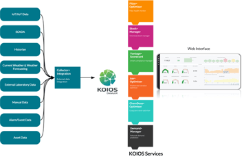
Veolia has developed SkyCam satellite image analysis technology using API services developed by Digital Content Analysis Technology (D-CAT) to proactively monitor and prevent blockages in Australia’s underground sewer networks.
Veolia’s algorithm employs sophisticated satellite image analysis to track the growth of vegetation surrounding underground water networks to preempt one of Australia’s most common causes of sewer blockages: tree roots.
Veolia CEO Richard Kirkman said the initiative is a game changer for underground network service maintenance that will significantly reduce costly network disruptions.
“Issues in the underground sewer network system had typically only been detectable when blockages had already occurred. Now, we can proactively identify high-risk locations for potential network disruptions and prevent them before they take place,” he said.
“This technology will save councils and taxpayers hundreds of thousands of dollars in repair costs, which can now be spent in other areas of need. It will also minimise the risks of sewage leaks, thus protecting the environment.
“This is really important for Veolia because it means we’re delivering on our purpose to become the global benchmark for ecological transformation.”
Aside from helping to mitigate tree root inundation into sewer networks, Kirkman said the technology is set to open new opportunities for a plethora of other water asset management challenges.
“The use of satellite-based technologies does not stop at the detection of blockages,” he said.
“We’ve also developed a range of applications to monitor soil movement, keep a watchful eye on landslide prevention, detect bushfire prone zones and measure leaking water from water mains.”
Sensing asset risk
SkyCam works by analysing satellite images, but the various applications of the new tool are achieved by using the data collected by satellites, which goes far beyond the satellite images we all have seen in Google maps, Veolia Smart Water Manager Quentin Bechet said.
“All the applications we are pursuing with SkyCam only require the analysis of satellite images. That’s the beauty of this technology – it’s simple, and very cost-effective,” he said.
“The satellites we’re using are taking a lot of images, and we use a variety of sensors that can detect things that are not visible to the human eye, like infrared radiation. We use lots of different wavebands from the satellite, and different types of sensor such as optical and radar, to get the information we are after.
“And by using this type of image analysis coupled with specific sensors we can actually get quite a lot of information about a whole variety of things.”
The SkyCam application for tree root inundation detection analyses tree growth around underground sewer networks – when trees begin to grow or show signs of additional nutrients, the algorithm detects a potential blockage or break in the network.
But Bechet said tree root inundation is just one network deficit the new technology can help with.
“One of the applications we are working on detects water leaks from pipelines by using satellite images to track the moisture content of the ground in the vicinity of pipes. This uses a multispectral sensor, to detect how much moisture levels have changed in the topsoil or vegetation above the water pipes,” he said.
“With the increasing scarcity of water resources in the decades to come, this type of technology will be key to minimise water losses in the future.”
Another application is able to measure soil erosion: “Again, we use satellite images, in this case using radar to derive extremely fine topographic measurements,” Bechet said.
“This application could be big for the water industry. We can detect soil movement in the vicinity of critical assets, like dams. Many water utilities have a yearly surveillance program as part of their asset management strategy to check this exact issue.
“But we think we can actually do this via satellite now, utilising our approach to satellite image sequencing, and give predictive advice in regards to when issues are likely to occur in future.”
Yet another potential application is for mitigating bushfire risk, Bechet said, with SkyCam particularly well suited to remote surveillance, and over large areas and at a frequency of every few days.
“We know that bushfires will be a problem again in future, particularly for the water industry. The financial value of assets managed by water utilities is in the order of dozens of billions of dollars,” he said.
“One of the simplest ways of helping curb the risk of damage is to keep infrastructure clear of overgrown vegetation. And utilities need to keep on top of these maintenance programs, because vegetation grows back.
“Furthermore, many water utilities have huge amounts of land to manage, and many assets located in places that aren’t always easy to access. By utilising the satellite data, these types of maintenance programs can become a lot easier, quicker and more effective.”
Bechet said there is also an application being explored for the detection of algal blooms, as well.
“Most of the raw water resources are surface waters in Australia – lakes, reservoirs, dams – and using satellite imagery to track blooms is a very cost-effective and efficient way to monitor surface water across vast distances,” he said.
Sky’s the limit
Bechet said that while using this type of satellite analysis for water sector applications is still new, they have proven to be very effective.
“We are just at the beginning as well. We’re really pushing the limits with these applications, but we are sure there will be more in future.”
Veolia and D-CAT have now entered into a mutually exclusive teaming agreement with the intent to extend the technology across Veolia’s global client base.
D-CAT CEO Phil McLachlan said the companies will develop new services within water management, bringing new opportunities to preserve the planet.
“D-CAT’s exclusive teaming with Veolia is a definitive step in the delivery of our proven satellite-derived monitoring, reporting and verification services across the water industry, worldwide,” he said.
“We are delighted and privileged to be collaborating with the global leader in the water industry. Over the coming years, D-CAT looks forward to maximising the potential of our collaboration to the sustainable benefit of Veolia and its water utility clients globally.”
The teaming agreement will run for an initial period of 3 years.
Share