Satellite monitoring reduces Hunter Water's inspection costs
Satellite data is now providing valuable asset management insights for Hunter Water’s Grahamstown Dam and Chichester Dam as part of a safety upgrade, with the approach expected to reduce inspection costs, as well as risks to employees.
Hunter Water has engaged Australian company Detection Services, in partnership with UK-based analytics company Rezatec, to increase the frequency and accuracy of monitoring over the next three years.
Hunter Water Dam Safety Engineer Daniel Turnbull said utilising advanced satellite technology was a game-changer for the organisation.
“We receive high-quality data showing any changes on a very fine scale, which gives us increased confidence in our dams’ integrity and allows us to proactively manage the assets,” Turnbull said.
“Satellite monitoring minimises the fieldwork required, reducing the exposure of our people to potential hazards.
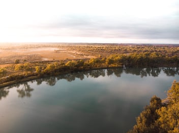
“This is particularly relevant when you realise Grahamstown Dam has a public road along its crest with an 80-kilometre-per-hour speed limit, and the terrain around Chichester Dam is steep and heavily forested.”
Turnbull said the digital technology program is part of the utility’s dedication to considering alternatives to traditional measurement surveys and visual inspections, which will improve resilience, deliver value to customers and protect the environment.
“We also wanted to establish a higher level of scrutiny than the minimum standard we’re required to demonstrate under the regulations,” he said.
While Hunter Water has trialled other technologies, including flying drones over the dams, these options did not offer the same level of insight.
“Drones just can’t achieve the millimetric accuracy of satellite data. Our comparisons showed drones can pick up potential movement with sensitivity of 20 to 30 millimetres, whereas satellite data detects movement of one to two millimetres. For dams, that’s hugely significant,” he said.
“We are utilising satellite monitoring to complement the traditional surveys undertaken at these sites as it can provide frequent updates on potential movement in a cost-effective manner between traditional survey cycles.”
The dam monitoring technology includes an online portal with a dashboard view, as well as detailed reports providing early information and analysis of any potentially irregular ground movement and vegetation growth.
Rezatec Product Manager Camilla Braithwaite said metrics like dam water level and seasonality could affect vegetation, with higher growth occurring during warmer, wetter periods, and that including this data to the analytics would enable additional insights.
“Vegetation, particularly any vigorous growth, is a good indicator for seepage, which is a focus area for dam owners,” she said.
“It’s not something they can spot immediately or easily. We provide dam operators with an understanding of what’s normal through benchmarking, or setting a baseline, and then identifying potential anomalies.”
Rezatec began the monitoring trial of Grahamstown Dam last year and Chichester Dam was added to the program this year following the trial’s success.
Hunter Water will now consider applying Geospatial AI technology to other assets across its network, including monitoring for leakage from remote trunk water mains.