First South Australian satellite to assist water management

The first-ever Australian-designed and owned satellite is a step closer to launch — and set to deliver a major boost to water management research.
Following the successful completion of the critical design review (CDR) for the South Australian Space Services Mission satellite, the project team is set to finalise the 6U spacecraft’s design, and initiate its manufacture and test phase.
The Kanyini Space Services Mission is being delivered by the South Australian government in partnership with South Australian companies, including Inovor Technologies and Myriota, as well as the SmartSat Cooperative Research Centre (CRC).
Inovor Technologies is responsible for Kanyini’s design and build, Myriota is leading the satellite’s Internet of Things (IoT) connectivity, and the SmartSat CRC is partnering with researchers and industry to develop new technologies and data applications.
Myriota co-founder and Chief Technology Officer Dr David Haley said the data collected by Kanyini will have enormous benefits for users here on Earth.
“The success of the Kanyini CDR marks the beginning of a new phase of the program where the Myriota and Inovor teams will proceed with assembly, integration and testing of the spacecraft and its two payloads,” Haley said.
“The Internet of Things payload will add to the Myriota Network, collecting data from devices and sensors on the Earth’s surface, working together with hyperspectral imaging collected from the earth observation payload to support a wide array of applications.”
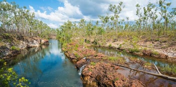
Kanyini is set to transform how water is viewed and managed, from aiding farmers in monitoring water to having near real-time information about remote water quality and groundwater levels and supporting emergency services personnel to monitor, manage and mitigate emergencies.
SmartSat CRC Chief Executive Officer Andy Koronios said Kanyini will provide water researchers with a vehicle to develop real-world technology based on their research to the benefit of a range of stakeholders.
“We are dedicated to developing satellite IoT connectivity technologies that help solve some of the biggest challenges facing Australian industries, and that includes water security for our environment, community and the economy,” Koronios said.
“The data captured by this satellite will help progress valuable research into satellite technology. We are continuing to look at new projects that will provide services for the South Australian government.”
Predicting water quality
One research partnership already underway between SmartSat CRC and CSIRO is AquaWatch Australia, which aims to establish a comprehensive ground-to-space national water quality monitoring system.
SmartSat CRC AquaWatch Capability Demonstrator Leader Dr Jasmine Muir said Kanyini will help demonstrate various components of the program’s auto-analytics supply chain of data technology, including exploring dedicated Earth-observation sensing for water quality monitoring as well as other science and information applications.
“We will be using the data we receive from Kanyini to test some of our water quality algorithms, and how we could use the hyperspectral data to help inform and make better water quality management decisions,” she said.
“AquaWatch is a satellite and IoT system, combined with data analytics, machine learning and AI, which will be able to predict water quality across very large areas.
“We are aiming to do this nationally, but it will also have a global scale and we are working with international researchers from different agencies on that as well.”
Muir said AquaWatch Australia is using the CSIRO’s water-quality modelling, with SmartSat CRC helping to fill technology research gaps.
“One of the things Kanyini will be testing for us is how we combine data from onboard image processing with data from our ground-based sensors to create a product that can identify and even predict water quality issues,” she said.
“It’s quite difficult to deploy enough ground sensors to cover everywhere in Australia. But by combining data from the ground sensors with data from the satellite, we are aiming to generate water quality predictions across much broader areas, and on a continuous basis.
“This is a new solution because it is pulling information in from multiple sources. Eventually, once we are further down the development path, we plan to make this information available to water managers so that they can make more informed decisions.”
Assessing groundwater
Another research project conducted through the SmartSat CRC has demonstrated reliable, cost-effective monitoring of the state government’s extensive network of groundwater bores.
Conducted with FrontierSI, Myriota, Uni SA, NGIS Australia and Department for Environment and Water, the project — SIGWater — resulted in the development of an end-to-end solution for transmitting and aggregating automatically collected information from bores across rural and regional South Australia, with a focus on environmental water monitoring.
SmartSat CRC Chief Executive Officer Andy Koronios said the project is leading the way in terms of bolstering groundwater management aims, and has the potential to be used globally.
“With over a third of the world’s biggest groundwater systems already in distress, this project will put Australia in pole position to be a global leader in groundwater management and apply the solution locally and abroad,” he said.
“It is fantastic to know that we can deliver this technology to space aboard a sovereign satellite such as Kanyini.”
With much of Australia’s groundwater being a main source of drinking water for many regional townships and used heavily by agriculture, mining and the energy sectors, FrontierSI Deputy CEO Phillip Delaney said the project has the potential to significantly optimise the management of this crucial water source.
“This project has created a wealth of information on groundwater, transforming once-per-year updates on groundwater into data points multiple times per day,” he said.
“This will be critical to underpinning decision-making, [being] reactive to events, and understanding the impacts of developments on the whole groundwater network.
“Importantly, as many of these sites are in hard, remote environments, there are substantial safety benefits gained by reducing the number of times these sites need to be visited.”
Next steps for Kanyini-informed research
Muir said a plan is currently being developed to identify and develop further projects that can use Kanyini data for a range of next-generation water management applications, with SmartSat CRC now open to research proposals from water managers in South Australia.
“We are looking for particular application areas and working with state government departments to identify the critical areas of interest for them so that we can develop research projects that demonstrate the ability of Kanyini data for all those applications,” she said.
“We are looking to work with people who are researching on the ground, as well, including water-quality managers in South Australia. We are open to discussing potential application areas that people are interested in testing.”