


Ancient groundwater beneath APY lands mapped
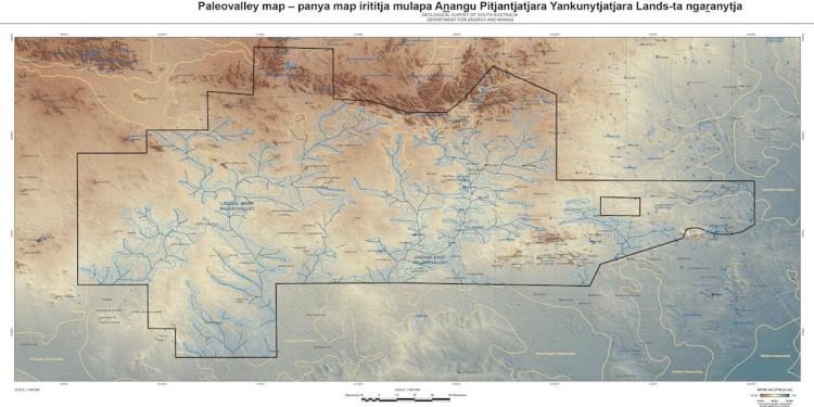
Ancient palaeovalley groundwater systems located below the Aṉangu Pitjantjatjara Yankunytjatjara (APY) lands in South Australia have been mapped by a team of water researchers.
Involving CSIRO, Flinders University and the Goyder Institute for Water Research, the project aims to investigate the viability of using underground palaeovalley systems as low-cost, groundwater resources for remote communities and enterprise.
Lead by CSIRO Research Director Dr Tim Munday and CSIRO Senior Research Scientist Dr Mat Gilfedder, the project team known as G-FLOWS has now created the most detailed and refined information on palaeovalleys across the whole APY region.
“This work is a big step forward and was supported by an 11 well drilling program, which provided critical insight into the palaeovalleys as a potential water resource,” Gilfedder told CSIRO.
“These valleys started to erode and form about 60 million years ago. For the last five million years they have been filled up with sediments and wind-blown sand and hidden from view.
“People have known about these valleys for a long time but knowing precisely where they are has been more difficult.”
The 10-year project included using existing mapping, conducting extensive airborne electromagnetic surveys, on-ground information via drilling, testing of water chemistry and environmental tracer analyses as well as groundwater modelling.
“This research gives a sense of what [the palaeovalleys] are made of and how the water quality varies,” Gilfedder said.
“At the main investigation site, while holes were drilled to 115 metres, the main water-bearing zones were around 50-65 metres below the surface.”
SA Department for Environment and Water Director Water Science and Monitoring Neil Power said the research has helped provide a better understanding of the location and capacity of these ancient water sources.
“Until now, there hadn’t been concentrated work to identify how much water these valleys might hold,” he said.
“This goes a long way to supporting possible future economic development, local community water supplies and water for agricultural purposes.”
While the report and final palaeovalley maps have been produced following the research, Gilfedder said further inquiry into these water sources will likely continue.
“We still have some questions about the timing and flow of water through these ancient palaeovalley systems, which will help to understand how to manage these potential water resources”, he says.
“They contain water that is of value for communities, environment and industry. To get all the answers, we will need additional exploration.”
