Remediating erosive gullies key to managing sediment runoff
Highly erosive “gullies” in Queensland's north have been found to contribute significantly to sediment runoff. In response, researchers are calling for support to better target remediation efforts, as concerns over water quality on the Great Barrier Reef continue to mount.
Griffith University researchers have spent the past 10 years identifying, mapping and tracking sediment runoff from erosive gullies, which are responsible for more than 400,000 truckloads of fine sediment finding its way to the reef lagoon every year.
The team has developed tools to identify and target the highest priority gullies, and have carried out research to trial and evaluate the most effective approach to remediate them.
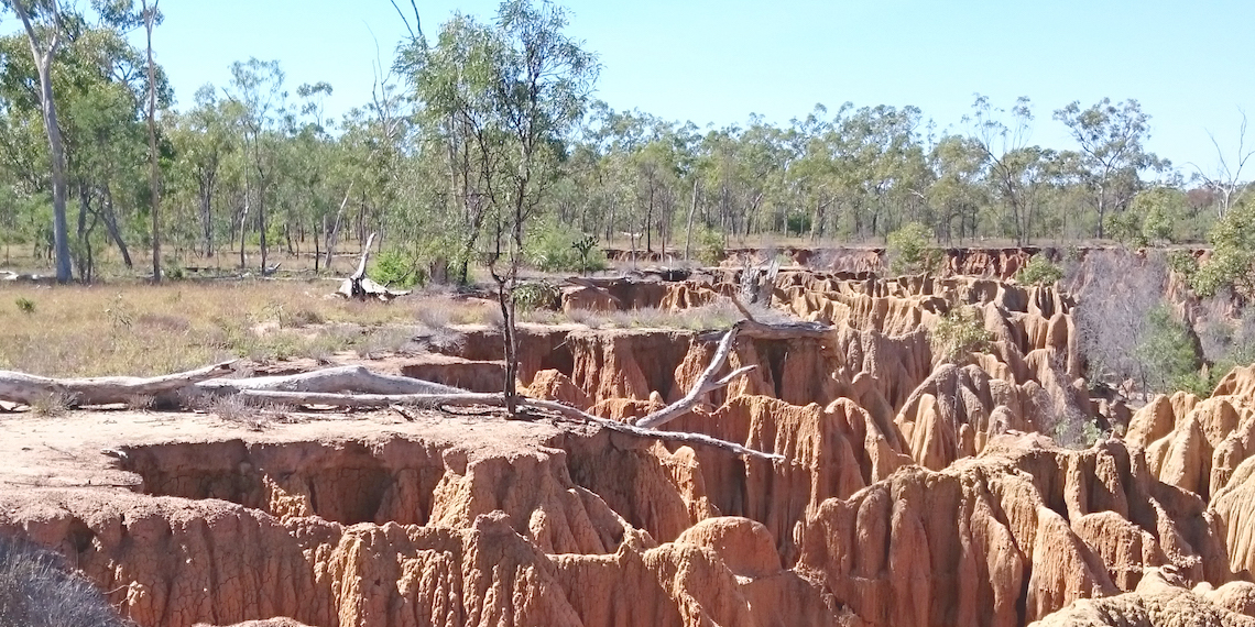
The most active gullies, known as alluvial gullies, are areas of incised, highly erodible land typically concentrated on floodplains within the dry tropics catchments – they form following disturbance of the topsoils, which exposes the highly reactive subsoil that has accumulated over tens of thousands of years, Griffith University Principal Research Fellow Andrew Brooks said.
“We’ve been doing a lot of work on gullies in the north, and it became apparent that these systems hadn’t been very well described in the literature, and their disproportionate contribution to the sediment loads in these tropical rivers had not been fully appreciated,” he said.
“One of the key things we’ve done in our research is to actually describe and track these alluvial gullies, and identify the ones that need to be remediated in order to meet reef water quality targets.”
Brooks said the gullies were initiated by cattle grazing on the floodplains, along with other disturbances, such as roads and fence lines. In the early days of grazing, cattle created tracks as they walked to rivers and streams when those were the only source of water.
“These tracks became preferential flow pathways that rapidly turned into gullies as the highly erodible subsoils below became exposed to the flowing water,” he said.
“Once this occurs, the gullies become self-perpetuating. They continue to erode and expand when they come into contact with rain water, regardless of whether or not cattle have been removed.”
Brooks said the subsoils are high in sodium or magnesium, making them highly reactive: “All these subsoils need is water and they just dissolve”.
“And once gullies are initiated, they spread until the gully itself becomes the whole catchment. The water that runs across the floodplain goes into these gullies, picking up all the sediment and moving it straight into the river system.”
Brooks said suspended sediment concentrations in gully outlets have been measured in excess of 100,000 milligrams per litre, or 10% sediment by mass.
“It turns the water into a sediment milkshake and contributes hugely to deteriorating water quality in marine environments,” he said.
“There are other sediment sources finding their way from the catchments into the ocean, but these gullies are particularly concentrated sources of sediments. Depending on the catchment, something like 40% of the sediment load is produced via these gullies.”
Reducing impact
In terms of impact, Brooks said it's the particularly fine sediment fragments that create problems for the reef’s unique marine environment.
“We are particularly focused on the silt and clay sediment fractions that are less than 20 microns in size. That very fine sediment creates turbidity when big flood waters make their way out into the reef lagoon,” he said.
“These particles also transport nutrients, which catalyse the growth of marine algae, and create very cloudy water, negatively impacting the ability of corals and seagrass to photosynthesise. This of course has knock-on effects for the reef’s entire food web.”
While the research team has built up a body of evidence confirming that big, highly active gullies are disproportionately contributing to water quality issues on the reef, they have also co-developed and trialed successful remediation processes to help reduce impact.
“We have to deal with these gullies via earthworks and soil stabilisation processes. It’s a bit like mining rehabilitation, but it’s got some differences,” he said.
“The process involves reshaping the gully, and also treating the chemistry of the soil itself to neutralise its reactivity, using gypsum or lime. We also use rock capping and organic mulch as well, to make sure the surface layer becomes more resilient to intense rainfall.
“This process has proven to be very effective. We have tested the process, and it’s proven to effectively shut down the sediment supply from the remediated gully within about one year. But we need to deal with this issue at the appropriate scale, and that is effectively where we are headed now with this work.”
Brooks said that while cattle grazing management has been trialed in the past, evidence has shown that once a gully has become large enough, no amount of grazing management will reverse the erosion process.
“We did some work in Cape York showing that these big gullies do not respond to grazing exclusion. Once they get to a certain scale, they self perpetuate. All they need is rain to do that,” he said.
“So a strategy focused on changing grazing practice alone won’t work. The only way to deal with these large and growing alluvial gully systems is to intervene with earthworks and soil regeneration processes.”
Modelling success
In order to help prioritise remediation works, the research team has mapped and tracked gullies and their erosion rates, identifying particularly problematic gully systems, Brooks said.
“Effectively mapping these gullies relies on having very high-resolution data. We use LiDAR data, which is high-resolution land surface topography data. It’s essentially a laser scanner mounted in a plane that flies across the landscape, scanning the ground’s surface,” he said.
“To do this sort of mapping at the scale that we need it, we need LiDAR data because it allows us to calculate the volume of these gullies. Not just where they are, but also their depth.
“We can also compare the terrain. We can measure the roughness of the gully's soil, and relate that to how much erosion is going on in that gully. We also go back over the same gullies years apart, which allows us to compare those data sets to see how much it has grown.
“This has allowed us to map the distribution of the gullies, and get a sense of how much sediment they are producing as well, down to the individual gully. When you do that across a whole catchment, you can then start to identify where the really problematic gullies are,” he said.
Time to act
Brooks said the project has so far mapped more than 25,000 individual gullies in three hot spot areas in the Normanby, Burdekin and Fitzroy River catchments.
“One of the worst catchments is the Bowen, which is a tributary of the Burdekin River. In the Bowen catchment, 2% of the gullies there contribute to over 30% of the sediment load,” he said.
“This is good news for managers, because it means we can identify the relatively small population of gullies that is disproportionately contributing to the sediment load. Then we can target the remediation efforts at those gullies.
“The latest UNESCO report made it very clear that Australia has got a lot of work to do in the short term to meet our targets around water quality on the Great Barrier Reef. And that’s why this data mapping is so crucial. It allows us to pinpoint the places where our efforts will make the greatest difference.”
Brooks said gully remediation is an issue that needs to be addressed, sooner rather than later.
“While we know which gullies we need to fix first, smaller gullies have the potential to become larger gullies – and will do so if left to erode,” he said.
“When targeting the large sources of current erosion, we can also cost-effectively treat the adjacent small gullies to prevent them from growing into major sources of erosion in the future.”
Image credit: John Spencer