S Thompson, M Shanafield, A Manero, G Claydon
First published in Water e-Journal Vol 6 No 1 2021.
Abstract
In Perth, Western Australia, “high” groundwater areas (i.e. where the groundwater is less than 4 m below ground) represent an important challenge for residents, real estate developers and public authorities. High groundwater is an indispensable resource supporting wetlands and vegetation. Yet current knowledge and management practices are lagging in their ability to maintain the benefits to hydrologic and ecologic systems, while reducing risks to urban infrastructure and open space. An Expert Panel was convened by the Cooperative Research Centre for Water Sensitive Cities (CRCWSC) in 2019-2020 to gain a better understanding of current practices for monitoring, modelling, and managing groundwater levels in urbanising sites. The study consisted of a literature review, followed by site inspections and in-depth interviews with water industry professionals from local government authorities, consulting firms, state government departments, and researchers based in Western Australia. Consultation was also undertaken with four urban development/water industry representative groups. The recommendations resulting from the investigation include a three-tier risk hierarchy indicating minimum modelling requirements for low-, medium- and high- risk sites. Improved groundwater management practices in Western Australia could not only mitigate impacts on public and private property but could also serve as guidance to other areas across the world, from Seattle to Taipei, where development of high groundwater areas entails similar challenges and opportunities.
Introduction
“Things are different in WA” is a common saying among urban stormwater professionals in Perth, Western Australia (WA). What is different about Perth compared to cities in the rest of the country? The answer is groundwater.
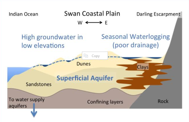
Perth is located on ancient sand dunes running north-south along the Swan Coastal Plain – a 40km wide stretch of land between the Indian Ocean and the “hills” of the Darling Escarpment to the city’s east. These sands are tens to hundreds of meters deep, and underlain by highly conductive sedimentary rocks (Geosciences Australia, 2020). The sands and rocks store vast amounts of groundwater and are a critical water supply for the Perth metropolitan area (Figure 1). Over the past two decades, population growth and changes in rainfall have resulted in declining water levels in the sandy aquifers (Ali et al., 2012).
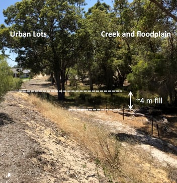
Less publicised are the areas with “high” groundwater (also referred to as “shallow” groundwater), where the water table is within 4m of the land surface (Figure 1 and Figure 2). This typically occurs in the swales between the sand dunes, where there are hundreds of wetlands. East of Perth, clayey soils on river floodplains are also prone to seasonally high groundwater. Unable to drain through clay soils, high groundwater saturates the landscape during wet, cool winter months. Many of Perth’s newer and proposed future suburbs are located in areas subject to high groundwater, posing difficulties for urban development.
Figure 1: Schematic illustration of Perth’s aquifer system. The superficial aquifer shown ranges in depth from ~1m over shallow clays to ~50m on deep sands. New urban developments are pushing the city limits north and south in areas of high groundwater/low topographic elevation, and east into areas underlain by shallow clay
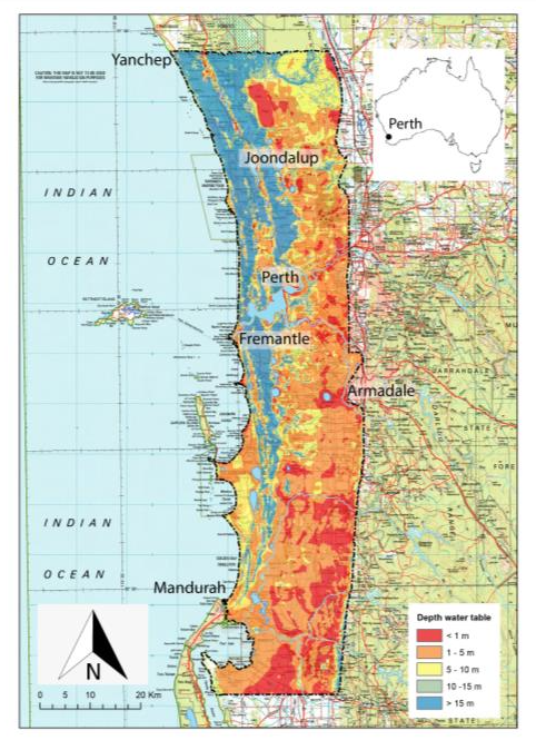 Figure 2: Depth to groundwater on the Swan Coastal Plain surrounding Perth City. Areas in orange or red have groundwater within the top 5m of the subsurface. Source Claydon et al. (2020)
High groundwater levels have many implications for urban development, which must be managed through stormwater drainage and treatment (Bhaskar et al., 2016). Impacts of high groundwater include the production of large volumes of stormwater, which can damage private and public infrastructure. Environmental damage can occur as the infiltration, streamflow, water quality, evapotranspiration, and groundwater components of the hydrologic cycle are altered. This is particularly critical where groundwater contains high concentrations of nutrients, as occurs in some locations around Perth (Barron et al., 2013).
Therefore, stormwater engineers in Perth need to make predictions about how groundwater levels change following urban development. Typically, urban stormwater design is informed by consistent guidelines for prediction and management. For example, both Australian Rainfall and Runoff (ARR, Ball et all., 2019) and the Institute of Public Works Engineering Australasia Western Australia guidelines (IPWEA, 2016) are useful resources. However, these guidelines do not offer full guidance for situations where high groundwater is present, leading to debate about how best to measure, model and manage high groundwater environments.
A consistent approach towards water management in high groundwater areas would benefit land developers, engineering consultants, regulators, society and the environment. To fill this gap, the Cooperative Research Centre for Water Sensitive Cities (CRWSC) established the “Knowledge-based water sensitive city solutions for groundwater impacted developments” Integrated Research Project, known as IRP5 (CRCWSC, 2017). Through this project, an Expert Panel was formed to produce a guidance note on recommended best-practices for monitoring, modelling and managing groundwater behaviour in urbanising sites.
In this paper we present the methods used by the Expert Panel and summarise the main technical guidance. A second paper based on the Expert Panel’s findings focuses on the potential benefits of changing on-lot techniques for groundwater management (Part 2). The full Expert Panel report is also available through the CRCWSC (Claydon et al., 2020), along with several related documents and emerging research.
Methods: Convening the expert panel
The Expert Panel (Chair Greg Claydon, panellists Dr Margaret Shanafield and Dr Sally Thompson, assisted by Research Associate, Dr Ana Manero), was convened from September 2019 to April 2020. The Panel’s brief was to review relevant literature and case studies, and consult with practitioners to formulate guidance on urban water management for land developments in areas subject to high groundwater, specifically on the Swan Coastal Plain. To address this brief, the panel conducted a study in two parts.
First, the panel reviewed recent academic literature and available guidance, with the purpose of identifying the status quo and knowledge gaps. Key findings of the literature review are reported in Claydon et al. (2020). The second part of the panel’s work was a series of in-depth case studies. The case studies were intended to build understanding of current practices across the land development industry, and identify barriers limiting the use of best-practices. Purposeful sampling methods were used to identify individuals and organisations with expertise in high urban groundwater on the Swan Coastal Plain. Regulators, urban planners, resource managers, local government authorities (LGAs), consultants to the urban development industry, and research academics were interviewed. This kind of methodology (intentional, rather than probabilistic sampling) is widely considered appropriate for qualitative, exploratory studies (Palinkas et al., 2015).
Participants were asked to present case studies illustrating: (i) best-practice; (ii) most commonly applied practices across the industry; and (iii) practices that could be improved. These were followed by semi-structured interviews. This open-ended format of presentation followed by interviews helped the Expert Panel identify information to fill existing knowledge gaps and questions needing further research. Presentation transcripts, interview notes, and material provided to the Panel were examined through thematic analysis (Braun & Clarke, 2012).
Case studies were provided by four LGAs, seven consulting firms, two academics, and one state government department. Confidentiality of participants’ identity and information provided was strictly observed, in line with the University of Western Australia (UWA) ethics protocol 2019/RA/4/20/5775. Further, case study locations and projects are not identified here or in the Expert Panel report.
The Panel’s study was also informed by consultation with and feedback from the Urban Development Industry Association's (UDIA) Water Committee for WA; the multi-stakeholder Land Development in Groundwater Constrained Environments Steering Group (convened by the Institute of Public Works Engineering Australasia (IPWEA) WA branch, and the Western Australian Local Governments Association – WALGA); the CRCWSC’s Western Region Advisory Panel; and Perth’s Water Sensitive Transition Network. The remainder of this paper, and its companion paper, present outcomes from the process of case study review and analysis.
Results
Why do we need to know about groundwater in urbanising sites?
Urbanisation generally increases surface runoff compared to natural landscapes due to the removal of vegetation and increase in impervious surface area (Schirmer et al., 2013). In Perth, this runoff is often infiltrated via soakwells, sumps, or bio-filtration basins. Combined with higher regional groundwater during winter, infiltration of urban stormwater can contribute to large increases in groundwater levels after rain. Such high urban groundwater can damage or undermine the structural integrity of infrastructure, including concrete housing foundations and bitumen roads. Costs for remediating damage to private and public infrastructure are significant. The Expert Panel viewed examples of remediated public open space where additional drainage and detention works had cost hundreds of thousands of dollars (Claydon et al., 2020). Therefore, either groundwater levels must be managed as part of urban stormwater design, or alternative construction methodologies (e.g. thicker concrete foundations) are needed to mitigate the risks. Typically in Perth, groundwater is managed by elevating the built surface with imported fill, and installing subsurface drains (“subsoils”) beneath the road reserve to protect the roadways and utility corridors (Figure 2).
This kind of management often means that groundwater levels are highest in the areas furthest away from roads. For example, groundwater may build up at the back of housing lots or in the centre of public open space areas. High groundwater in these areas is problematic. As case study interviews revealed, “no one is keen on a game of cricket or football in a mud puddle, where grass or other plants will not grow and mosquitos breed” (Figure 3).
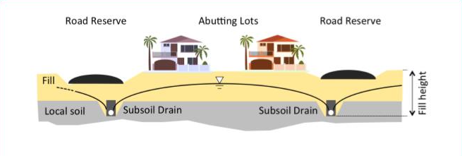 Figure 2: Typical layout of subsoil drains, roads, lots and use of fill in the Perth area. Road reserves (and associated utility corridors) are protected by local subsoil drains. This leads to the peak of the groundwater mound occurring in the rear of housing lots. Note that the fill height shown is a maximum depth of fill from the depth of the subsoil drain to the surface. Source: Author’s drawing adapted from Peel Development Commission (2006)
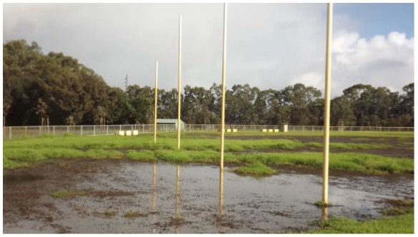 Figure 3: Groundwater flooded sports fields. Source: Predovnik (2015)
Not only does high groundwater risk damaging the built environment, the natural environment is also at risk. Groundwater discharges into wetlands and surface drains in the Perth area (e.g. Adyel et al., 2015), and may have elevated concentrations of nutrients and salts relative to rain (Barron et al., 2013; Donn & Barron, 2013). Increasing groundwater discharge can adversely impact on the temperature, salinity, and nutrient status of receiving waters, for example by promoting algal blooms (Roy et al., 2009). These impacts can be hard to prevent because treatment using water sensitive urban design methods may be less effective when high groundwater is present (Ocampo et al., 2017). Designing treatment infrastructure while accommodating the influence of high groundwater is thus an open challenge for water sensitive urban design in Perth.
What do we need to predict?
The Western Australian planning process and regulatory frameworks require water management to be considered in most detail when individual land parcels are developed. Consequently, most predictions must be made on the scale of urban subdivisions. Consultants need to predict the elevation of the water table following development, which is known as the controlled groundwater level or CGL. Predictions consider factors such as climate, soil, pre-development groundwater levels, the urban form including lot size, location and impervious surface areas, stormwater management infrastructure, and the depth and location of subsoil drains. There are several areas where immediate recommendations can be made to improve predictions. For example, standardising the measurement of soil hydraulic conductivity on site and after compaction, rather than relying on supplier-provided specifications, would improve models of subsurface drain performance.
Other modelling challenges are more complex. Within a subdivision, water table elevation will vary through both space and time. Through space, it is the highest elevations of the water table that are most important to manage. Guidance is offered as to how close the water table peaks should be allowed to come to the land surface (IPWEA,
2016). Different recommendations apply to different land uses such as public open space, sports fields, roads or housing. There is general agreement across the industry that existing guidance (IPWEA, 2016) is for the most part clear and reasonable, although specific land use recommendations are still debated.
There is less clarity about how to handle variations in the water table level over time. Urban stormwater design typically handles variability by specifying the acceptable risk of failure. Here, this would represent the frequency with which the water table exceeds the specified clearance level. Water management infrastructure would then be designed to meet this level of risk. This risk-based approach is not formalised for designing groundwater management in Perth. Instead, IPWEA (2016) recommends the use of the 72 hour, 50% annual exceedance probability (AEP) rainfall event as an input to models that evaluate the water table elevation. However, it is unlikely that this translates into a 50% AEP of groundwater levels exceeding the recommended levels. This is because groundwater variations due to a rainfall event are superimposed on a strong seasonal hydrograph. Peak water table heights therefore reflect both event characteristics and antecedent conditions over timescales of days to months (Cuthbert et al., 2019).
This lag in groundwater response poses a challenge to the status quo for estimating groundwater levels in urbanising sites around Perth. The most widely used methods include steady state, one-dimensional drainage equations or statistical analysis of historical (pre-development) groundwater elevations. Fully addressing the “long memory” of groundwater with modelling may require instead using (i) transient models, (ii) long timescales, and (iii) Monte Carlo approaches (across observed historical or randomly realised synthetic rainfall timeseries). This is similar to current guidance given by ARR for surface flows, which now recommends using ensemble and Monte Carlo approaches to estimate flow exceedance probabilities (Ball et al., 2019). Clearly, complex models will not always be necessary, and guidance could address matching model complexity to site risk, as is also done for surface flows in ARR already. To support this, the Expert Panel proposed a risk-based hierarchy of design and modelling approaches.
A risk-based hierarchy
The proposed risk-based hierarchy to guide prediction is summarised in Table 1. This table firstly summarises significant risk factors for high groundwater.
Some risk factors are mostly associated with groundwater levels. Undeveloped sites with high groundwater are riskier than sites with deep water tables. Similarly, sites where urbanisation will cause large changes to the local water balance are high risk. For example, urbanisation of agricultural lands that withdraw groundwater for irrigation are at risk of large water table rises if groundwater withdrawals stop (or a significantly reduced) with urbanisation.
Other risk factors are related to environmental quality. Contaminated groundwater is high risk compared to locations with good quality groundwater. Sites located near environmentally significant areas are higher risk. Risks can also be hydraulic, and could be associated with cumulative impacts of development, or with cumulative risks. For example, areas of high groundwater that are also located on floodplains would face the risk of both surface water and groundwater flooding, and consequently would require a high standard of investigation and design.
The Expert Panel’s broad recommendation is that statistical analyses of historical groundwater levels or one-dimensional modelling are appropriate methods to use on low-risk sites. Model complexity should increase, however, in parallel with risk. The specific modelling approach should be tailored to the site – a complex model might be 3D, or it might be a transient 1D approach. Additionally, all sites should be considered on a case-by-case basis. The presence of a single risk factor will not necessarily mean that a site is high risk, when all factors are considered. We hope, however, that outlining risk factors and aligning them with prediction and design requirements can form a blueprint for more refined future guidance.
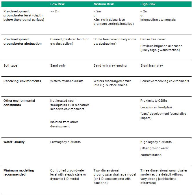 Table 1: Suggested risk matrix and recommended modelling methodologies required. In this table, “gw” stands for “groundwater”, GDEs for “groundwater dependent ecosystems”.
Discussion: What next?
The Expert Panel’s study found that the status quo for predicting and mitigating the impacts of high groundwater on urban development in the Swan Coastal Plain of Western Australia is not always adequate.
A lack of regulator confidence in prediction approaches has contributed to conservative development practices. Some of these practices increase development costs and impact housing affordability. For example, in many areas large volumes of sand fill are imported, which substantially effects the baseline cost of a house (see Part 2). Conversely, insufficient mitigation of high groundwater has led to nuisance flooding, damage to public and private infrastructure, water quality deterioration, and changes to groundwater dependent ecosystems.
Results of the Expert Panel’s study built on and added to otherwise limited sector-wide technical guidance. A lack of data, information and knowledge, along with process, regulatory and capacity barriers currently prevent the urban water management sector from achieving best-practices in groundwater management. As a priority, the Expert Panel recommended that work continue to:
- improve understanding of recharge dynamics of the pre- and post-development landscape,
- improve understanding of the risks associated with common modelling assumptions, and
- develop tools to facilitate the assessment of water management plans by local government authorities.
There are positive opportunities for industry, regulators and academia to work closely together to address these priorities. The existing efforts by stakeholders in WA to improve practice in a collaborative fashion are tremendously heartening. This situation presents a win-win-win opportunity for the public, the environment, and for land development interests by altering the status quo. This opportunity is explored in more detail in the companion paper.
There remains, however, a role for national bodies to help guide industry practice. Existing national stormwater management guidance generally neglects the role of groundwater as a driver of urban flooding and a contributor to urban stormwater production and quality. Addressing the implications of high groundwater for urban water management in national guidance such as ARR would be a helpful step.
Doing so would address the existing gaps in ARR’s coverage of urban water management in high groundwater environments. It would also provide a consistent definition of best-practices for urban groundwater modelling and design. Moving towards an AEP-based approach to water table prediction and groundwater management design would bring high groundwater environments into line with other urban water design practices.
To develop such guidance would require reaching better consensus on acceptable clearance levels to the water table based on different components of the urban environment. Each urban land use type and its groundwater clearance would then also be associated with an AEP that reflected the tolerance of flooding/waterlogging in each context. Finally, appropriate modelling methods to evaluate the AEPs would be outlined. Developing such a methodology might also require creating improved parameterisations and datasets against which models can be tested. Further research and consultation to this end is beginning with the second stage of the IRP5 project, which is making detailed measurements of recharge and water balance in urbanising sites in Perth.
Although it is high urban groundwater that makes it “different in Perth”, Perth is not, globally, all that unusual. Our recent estimates (Sytsma & Thompson, 2021) suggest that high groundwater influences ~40% of the world’s major cities. Developing best-practices for its management could position Australia as an ongoing leader in water sensitive urban design and urban stormwater management.
Acknowledgements
The authors deeply thank all study participants for their time and openness in sharing information. We would also like to thank the following organisations for their feedback and input: Urban Development Industry Association's (UDIA) Water Committee for WA, the multi-stakeholder Land Development in Groundwater Constrained Environments Steering Group (convened by the Institute of Public Works Engineering Australasia (IPWEA) WA branch and the Western Australian Local Governments Association - WALGA), the CRCWSC’s Western Region Advisory Panel and Perth’s Water Sensitive Transition Network. We also thank Prof. Carolyn Oldham from the UWA for her valuable feedback and support.
The research project was funded by the Cooperative Research Centre for Water Sensitive Cities, Integrated Research Project 5 Stage 2. To contribute to this paper, Ana Manero was supported by the Australian Research Council, under project FL190100164.
About the authors
Sally Thompson | Sally Thompson is an Associate Professor of Environmental Engineering at the University of Western Australia. Sally is Editor in Chief of the Journal of Hydrology, holder of the US National Science Foundation’s CAREER Award and the American Geophysical Unions Early Career Hydrology Award.
Margaret Shanafield | Margaret Shanafield is a Senior Researcher and Senior Lecturer at the National Centre for Groundwater Research and Training and the College of Science and Engineering at Flinders University, in Adelaide, SA. Her research focusses on surface water-groundwater interactions. She is a 2020 South Australia Young Tall Poppy award winner and was the recipient of a 2015 Australian Research Council Discovery Early Career Research Award to investigate how rainfall becomes streamflow in intermittent rivers, and how this streamflow recharges our aquifers.
Ana Manero | Ana Manero post-doc research fellow at the ANU Crawford School of Public Policy, working on water economics and governance. Ana’s research interests are around water management and its socio-economic implications. Ana also holds an adjunct research fellow position at the University of Western Australia.
Greg Claydon | Greg Claydon is a member of the board of directors of the Cooperative Research Centre for Water Sensitive Cities (CRCWSC). Greg has extensive water industry knowledge, built through his roles as a senior executive with Queensland’s and Western Australia’s state government water, environment and natural resources agencies. In 2009, Greg was awarded a Public Service Medal (PSM) by the Governor-General of Australia in the Australia Day Honours Awards for outstanding public service in natural resources management and water reform.
References
Adyel, T. M., Conti, A. L. R., Ocampo, C. J., Coletti, J. Z., Hipsey, M. R., & Oldham, C. E. (2015, 28 June - 3 July 2015). Ecohydrology and stormwater nutrient attenuation performance of constructed wetland in Western Australia. 36th International Association for Hydro-Environment Engineering and Research World Congress, The Hague, The Netherlands.
Ali, R., McFarlane, D., Varma, S., Dawes, W., Emelyanova, I., Hodgson, G., & Charles, S. (2012, 2012/12/19/). Potential climate change impacts on groundwater resources of south-western Australia. Journal of Hydrology, 475, 456-472. https://doi.org/10.1016/j.jhydrol.2012.04.043
Ball, J., Babister, M., Nathan, R., Weeks, W., Weinmann, E., Retallick, M., Testoni, I., & (Editors). (2019). Australian Rainfall and Runoff. A Guide to Flood Estimation. Commonwealth of Australia (Geoscience Australia). http://book.arr.org.au.s3-website-ap-southeast-2.amazonaws.com/
Barron, O. V., Barr, A. D., & Donn, M. J. (2013, 2013/01/15/). Evolution of nutrient export under urban development in areas affected by shallow watertable. Science of The Total Environment, 443, 491-504. https://doi.org/10.1016/j.scitotenv.2012.10.085
Bhaskar, A., Beesley, L., Burns, M. J., Fletcher, T., Hamel, P., Oldham, C., & Roy, A. H. (2016). Will it rise or will it fall? Managing the complex effects of urbanization on base flow. Freshwater Science, 35(1), 293-310.
Braun, V., & Clarke, V. (2012). Thematic analysis. In APA handbook of research methods in psychology, Vol 2: Research designs: Quantitative, qualitative, neuropsychological, and biological. (pp. 57-71). American Psychological Association. https://doi.org/10.1037/13620-004
Claydon, G., Thompson, S., Shanafield, M., & Manero, A. (2020). Guiding urban water management in areas that experience high seasonal groundwater: Expert Panel report. https://watersensitivecities.org.au/content/guiding-urban-water-management-in-areas-that-experience-high-seasonal-groundwater-expert-panel-report/
CRCWSC. (2017). Project IRP5. https://watersensitivecities.org.au/content/project-irp5/
Cuthbert, M., Gleeson, T., Moosdorf, N., Befus, K. M., Schneider, A., Hartmann, J., & Lehner, B. (2019). Global patterns and dynamics of climate–groundwater interactions. Nature Climate Change, 9(2), 137-141.
Donn, M. J., & Barron, O. V. (2013). Biogeochemical processes in the groundwater discharge zone of urban streams. Biogeochemistry, 115(1), 267-286. https://doi.org/10.1007/s10533-013-9833-5
Fan, Y., Li, H., & Miguez-Macho, G. (2013). Global Patterns of Groundwater Table Depth. Science, 339(6122), 940-943. https://doi.org/10.1126/science.1229881
Geosciences Australia. (2020). The Perth Basin. Retrieved December 8 from https://www.ga.gov.au/scientific-topics/energy/province-sedimentary-basin-geology/petroleum/offshore-southwest-australia/perth-basin
IPWEA. (2016). Specification Separation distances for groundwater controlled urban development. https://secure.ipwea.org/Web/WA_Resources/Specifications_and_Guidelines/Specification_Separation_distances_for_groundwater_controlled_urban_development.aspx
Ocampo, C., Rennie, B., & Oldham, C. (2017). Performance of two urban stormwater biofilters in an area with seasonally high groundwater. CRCWSC.
Palinkas, L. A., Horwitz, S. M., Green, C. A., Wisdom, J. P., Duan, N., & Hoagwood, K. (2015). Purposeful Sampling for Qualitative Data Collection and Analysis in Mixed Method Implementation Research. Administration and policy in mental health, 42(5), 533-544. https://doi.org/10.1007/s10488-013-0528-y
Peel Development Commission. (2006). Peel Harvey Coastal Catchment water sensitive urban design technical guidelines. https://www.epa.wa.gov.au/sites/default/files/Policies_and_Guidance/AppendixE_2.pdf
Predovnik, R. (2015, March 12, 2015). Woodbridge school in 'turf war' over unused state-of-the-art oval. WAtoday. https://www.watoday.com.au/national/western-australia/woodbridge-school-in-turf-war-over-unused-stateoftheart-oval-20150312-142qzg.html
Richts, A., Struckmeier, W. F., & Zaepke, M. (2011). WHYMAP and the Groundwater Resources Map of the World 1:25,000,000. In J. A. A. Jones (Ed.), Sustaining Groundwater Resources: A Critical Element in the Global Water Crisis (pp. 159-173). Springer Netherlands. https://doi.org/10.1007/978-90-481-3426-7_10
Roy, A. H., Dybas, A. L., Fritz, K. M., & Lubbers, H. R. (2009). Urbanization affects the extent and hydrologic permanence of headwater streams in a midwestern US metropolitan area. Journal of the North American Benthological Society, 28(4), 911-928.
Schirmer, M., Leschik, S., & Musolff, A. (2013, 2013/01/01/). Current research in urban hydrogeology – A review. Advances in Water Resources, 51, 280-291. https://doi.org/10.1016/j.advwatres.2012.06.015
Sytsma, A., & Thompson, S. (2021). Map of global urban exposure to groundwater.
Share